Spatial History
Spatial History is the consideration of geological factors, typically using visualizations, to contextualize historical events. Maps today look way different than they did hundreds of years ago, and it is important for historians to consider this when conducting research. For example, state, local, and national borders can be redrawn depending on the people in power. Territory can change ownership after two parties fight. Over time, natural disasters can change the geographical landscape, however humans can build structures that add to it. Considering how maps were drawn during the time being researched is essential to completely contextualize historical events, and why things happened the way they did. Maps offer a visual context that most brains wouldn’t be able to comprehend, such as a mapping of battles in different states would be more effective than communicating their individual locations by relative location or longitude and latitude.
Gerrymandering
Gerrymandering is the redistricting of electoral boundaries in an order that usually favors the perpetrator and quite often, doesn’t make sense. The term ‘gerrymandering’ originates from a map in the Boston Gazette that depicts the newly redrawn border of a district in Massachusetts that resembled a salamander, and the governor who was responsible, Elbridge Gerry. The concatenation of ‘Gerry’ and ‘salamander’ resulted in the term ‘gerrymandering’ which is still used today. You may be wondering, how can borders being redrawn be used to manipulate elections? Would the same people not just be voting in a different district? At face value this seems to be the case, but it is not true because of worthless votes. For example, consider “District A”, where Candidate Two wins by a vote of 51%-49%, all of those 49% of votes contributed towards nothing. Now let’s say “District B” is next to said district, and Candidate One wins by a landslide, 80%-20%. Candidate One has a lot of wasted votes in District B, as they only need 51% to win that district. Now, gerrymandering can be used to relocate some of the population from District B to District A, and now Candidate One wins District A by a 55%-35% margin and still maintains the majority of votes in District B. It doesn’t just have to be done by one candidate though, as parties in power may redistrict in order to get other candidates in their party to win. Gerrymandering has made irreversible impacts throughout American history that are beyond comprehension. Lawmakers that have benefitted from gerrymandering have contributed towards a legislature that would not have been composed without them.
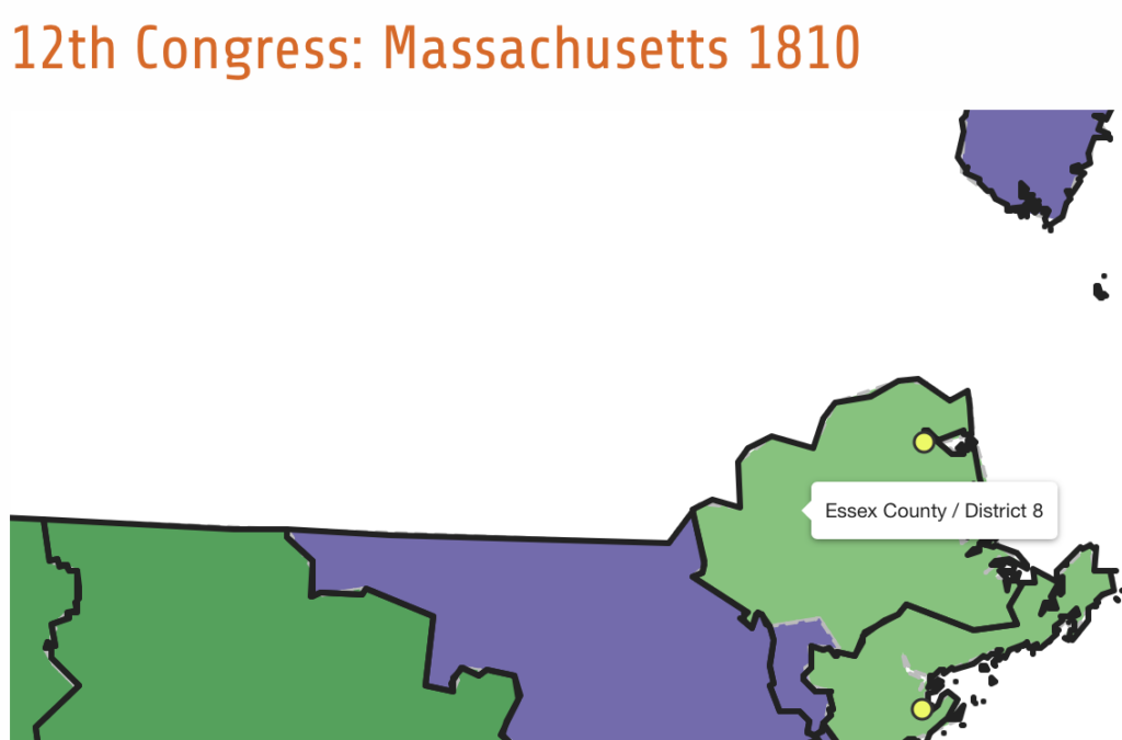
“12th Congress: Massachusetts 1810,” Mapping Early American Elections, https://earlyamericanelections.org/maps/meae.congressional.congress12.ma.county.html
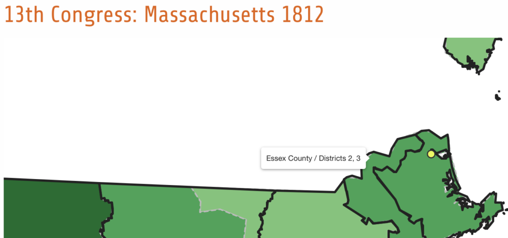
“13th Congress: Massachusetts 1812,” Mapping Early American Elections, https://earlyamericanelections.org/maps/meae.congressional.congress13.ma.county.html
In these maps, I included the redistricting of Essex County in Massachusetts in the early 18th century, which was where gerrymandering originated from. In the 13th congress, you might be able to make out the salamander shaped redistrict. Massachusetts went from electing less than half federalists to congress to 80% after gerrymandering this time. These maps explain my topic as it was the first concrete example since the term ‘gerrymandering’ was coined. The biggest takeaway from this is that you should consider why certain people have won certain elections, and how it has drastically impacted American history. Maps are the only way to visualize redistricting, and they can be used to call out lawmakers on manipulative redistricting.
Leave a Reply